


Go hiking, cycling, running or any other activity with Altimeter - Mountain GPS Tracker! Track your routes and record all of your data such as max and average elevation, distances and climbing time.


We have developed a brand-new independent application specifically for your watch device. Turn on our wearable application and enjoy our tracking data without worrying about your phone. Moreover, you can also get access to your current heart rate! When you finish tracking, just press the 'Save' button to automatically synchronize your track with your device.

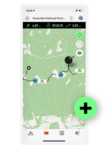
Track your routes using the real time map view! Zoom in and out to see where you were at a given time. Quickly see what altitudes you were at in a given place. Take a look at our multiple chart modes, such as elevation over distance and time or speed over distance and time to get a better understanding of when and where your top speeds occurred or maybe for how long you kept a steady ride!
New maps based on Open Street Maps have been added to the application. You can now enjoy a fresh new look to your tracks. Moreover, you can now download a portion of a map for offline use, so that when you're on a trip with restricted access to WIFI, you can still enjoy the map display.

More precise data tracking - improved functionality of your routes and data collection for more precise results and deeper analytics.

Using the advanced analysis inside the application, you can see the division of your track into individual segments, uphill and downhill. You have the option to enter data into the app, then you can see a highlighted section of the track on the map, elevation and speed charts, as well as distance, time, and speed data of each segment.

Enrich your trip with pictures! While hiking, use the camera button to snap pictures of the beautiful views, take shots of you and your friends, or anything else you want. Choose what kind of data you want to display on the pictures, and share them with your folks! What's even cooler is that you can use the map view at any point to see the exact time and place where your photos were taken!
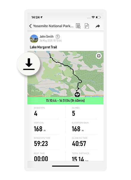
The history screen now has a fresh new look. It's more user friendly and intuitive than before and it’s now divided into a couple of sections to display your data - map, detailed trip data, chats, photos and segments.

You can easily export your tracks to three popular formats: a universal GPX format from which you can import your data to most devices and applications, as well as the KML and KMZ formats that allow you to see your track in Google Earth and Google Maps.

Add a waypoint when you want to mark places along the route, such as viewpoints, dangerous spots during a trip or any places you wish to come back to. In the map view, you will have the opportunity to see these points along with your descriptions.
Login through Facebook, Apple, Google or with your email account and have all your data secure! Our Altimeter app will store all your trip data, map routes, and photos in our cloud services. Want to see your data on another device? Not a problem. Just log in and our app will synchronize all your data instantly!


Our app calculates and displays data from three sources - a gps receiver, network services and a built-in pressure sensor. You have the option of turning off and on different sources if they lack accuracy.
Take a quick look at the manual altimeter view in the middle of a trip, it shows current elevation and pressure values, and you can quickly swipe your trip’s elevation chart.


See your trip details on four different charts - elevation over distance, elevation over time, speed over distance and speed over time to get most of our trip analytics and to best understand your trip profile.

If you have any ideas about functionality or cool features we add to our application feel free to contact us. If you spotted a bug or wrong app behavior let us know as well.
If you have any questions or problems with our application feel free to contact us.

 English
 Deutsch
 Español
 Français
 Italiano
 日本の
日本の Português
 русский
